Dataset Identification:
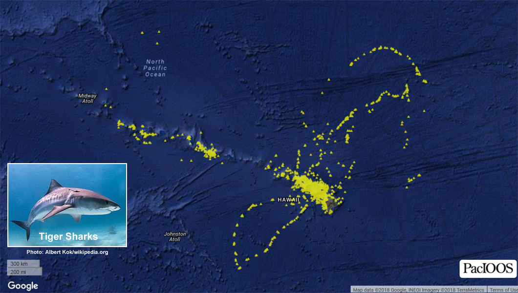
- This dataset contains a collection of known point locations of tiger sharks identified via automated satellite tracking of tagged organisms. This can be useful for assessing species abundance, population structure, habitat use, and behavior. This collection is aggregated from multiple tagged organisms and survey periods. Each data point contains attributes for further information about the time and source of the observation. This dataset was compiled by the Pacific Islands Ocean Observing System (PacIOOS) and may be updated in the future if additional data sources are acquired. University of Hawaii's Hawaii Institute of Marine Biology (HIMB) desploys satellite tags on tiger sharks to track their movements within the Main Hawaiian Islands as well as the Papahanaumokuakea Marine National Monument (Northwestern Hawaiian Islands). Top predators play an important role in ecosystems by influencing prey behavior and shaping communities through trophic cascades. For further information, please see: http://www.himb.hawaii.edu/ReefPredator/Tiger%20Shark%20Research.htm
- Title Species Distribution: Tiger Shark - Hawaii
- creation Date 2018-01-31
- organisation Name Pacific Islands Ocean Observing System (PacIOOS)
- Contact information
-
- Address
-
- electronic Mail Address info@pacioos.org
- Linkage for online resource
-
- name
- URL: http://pacioos.org
- protocol http
- link function information
- Description
- target application profile web browser
- individual Name Kim Holland
- organisation Name Hawaii Institue of Marine Biology (HIMB)
- Contact information
-
- Address
-
- electronic Mail Address kholland@hawaii.edu
- Linkage for online resource
-
- name
- URL: http://www.himb.hawaii.edu/ReefPredator/
- protocol http
- link function information
- Description
- target application profile web browser
- individual Name Carl Meyer
- organisation Name Hawaii Institue of Marine Biology (HIMB)
- Contact information
-
- Address
-
- electronic Mail Address carlm@hawaii.edu
- Linkage for online resource
-
- name
- URL: http://www.himb.hawaii.edu/ReefPredator/
- protocol http
- link function information
- Description
- target application profile web browser
- organisation Name Pacific Islands Ocean Observing System (PacIOOS)
- Contact information
-
- Address
-
- electronic Mail Address info@pacioos.org
- Linkage for online resource
-
- name
- URL: http://pacioos.org
- protocol http
- link function information
- Description
- target application profile web browser
Theme keywords (theme):
Earth Science > Biological Classification > Animals/Vertebrates > Fish > Sharks/Rays/Chimaeras > Sharks > Tiger Shark
Earth Science > Biosphere > Aquatic Ecosystems > Marine Habitat
- Title GCMD Science Keywords
Location keywords:
Continent > North America > United States Of America > Hawaii
Ocean > Pacific Ocean > Central Pacific Ocean > Hawaiian Islands
- Title GCMD Location Keywords
project
Keywords
PacIOOS > Pacific Islands Ocean Observing System
- Title GCMD Project Keywords
dataCenter
Keywords
PacIOOS > Pacific Islands Ocean Observing System
- Title GCMD Data Center Keywords
Theme keywords (theme):
- Title Science Domain > Earth Science
- publication Date 2018-11-21
Theme keywords (theme):
- Title Realm > Geosphere
- publication Date 2018-11-21
Theme keywords (theme):
- Title Realm > Habitat
- publication Date 2018-11-21
Theme keywords (theme):
- Title Resource Type > Dataset
- publication Date 2018-11-21
Theme keywords (theme):
- Title Science Domain > Biology
- publication Date 2018-11-21
Theme keywords (theme):
- Title Realm > Planetary Structure
- publication Date 2018-11-21
Theme keywords (theme):
- Title Activity > Observation
- publication Date 2018-11-21
Theme keywords (theme):
- Title Feature > Hydrologic Feature
- publication Date 2018-11-21
Theme keywords (theme):
- Title Process > Biological Process
- publication Date 2018-11-21
Theme keywords (theme):
- Title Feature > Marine Feature
- publication Date 2018-11-21
Theme keywords (theme):
- Title Material > Biological Material
- publication Date 2018-11-21
Theme keywords (theme):
- Title Property > Measure
- publication Date 2018-11-21
Theme keywords (theme):
- Title Realm > marine
- publication Date 2018-11-21
Theme keywords (theme):
- Title Organization > CONSORTIA/INSTITUTIONS
- publication Date 2018-11-21
purpose:
Browse image (thumbnail):
- Legal Constraints
-
- Use Limitation
- The data may be used and redistributed for free but is not intended for legal use, since it may contain inaccuracies. Neither the data Contributor, University of Hawaii, PacIOOS, NOAA, State of Hawaii nor the United States Government, nor any of their employees or contractors, makes any warranty, express or implied, including warranties of merchantability and fitness for a particular purpose, or assumes any legal liability for the accuracy, completeness, or usefulness, of this information.
Resource extent
-
- extent Type Code 1
- westBoundLongitude -175.757
- eastBoundLongitude -146.933
- northBoundLatitude 33.408
- southBoundLatitude 13.6315
Geographic Bounding Box
Geographic Extent
- The Pacific Islands Ocean Observing System (PacIOOS) is funded through the National Oceanic and Atmospheric Administration (NOAA) as a Regional Association within the U.S. Integrated Ocean Observing System (IOOS). PacIOOS is coordinated by the University of Hawaii School of Ocean and Earth Science and Technology (SOEST).
- organisation Name Pacific Islands Ocean Observing System (PacIOOS)
- Contact information
-
- Address
-
- electronic Mail Address info@pacioos.org
- Linkage for online resource
-
- name
- URL: http://pacioos.org
- protocol http
- link function information
- Description
- target application profile web browser
Service Identification information: 1
- This dataset contains a collection of known point locations of tiger sharks identified via automated satellite tracking of tagged organisms. This can be useful for assessing species abundance, population structure, habitat use, and behavior. This collection is aggregated from multiple tagged organisms and survey periods. Each data point contains attributes for further information about the time and source of the observation. This dataset was compiled by the Pacific Islands Ocean Observing System (PacIOOS) and may be updated in the future if additional data sources are acquired. University of Hawaii's Hawaii Institute of Marine Biology (HIMB) desploys satellite tags on tiger sharks to track their movements within the Main Hawaiian Islands as well as the Papahanaumokuakea Marine National Monument (Northwestern Hawaiian Islands). Top predators play an important role in ecosystems by influencing prey behavior and shaping communities through trophic cascades. For further information, please see: http://www.himb.hawaii.edu/ReefPredator/Tiger%20Shark%20Research.htm
- Title Species Distribution: Tiger Shark - Hawaii
- creation Date 2018-01-31
- organisation Name Pacific Islands Ocean Observing System (PacIOOS)
- Contact information
-
- Address
-
- electronic Mail Address info@pacioos.org
- Linkage for online resource
-
- name
- URL: http://pacioos.org
- protocol http
- link function information
- Description
- target application profile web browser
Resource extent
-
- extent Type Code 1
- westBoundLongitude -175.757
- eastBoundLongitude -146.933
- northBoundLatitude 33.408
- southBoundLatitude 13.6315
Geographic Bounding Box
Geographic Extent
- Operation name: GetCapabilities
- Linkage for online resource
-
- name OGC-WMS
- URL: http://geo.pacioos.hawaii.edu/geoserver/PACIOOS_WMS_ONLY/hi_pacioos_all_shark_tiger/ows?service=WMS&version=1.3.0&request=GetCapabilities
- protocol OGC:WMS
- link function download
- Description Open Geospatial Consortium Web Map Service (WMS). Supported WMS versions include 1.1.1 and 1.3.0. Supported map formats include AtomPub, GeoRSS, GeoTIFF, GIF, JPEG, KML/KMZ, PDF, PNG, SVG, and TIFF. Supported info formats include GeoJSON, GeoJSON-P, GML, HTML, and plain text.
Service Identification information: 1
- This dataset contains a collection of known point locations of tiger sharks identified via automated satellite tracking of tagged organisms. This can be useful for assessing species abundance, population structure, habitat use, and behavior. This collection is aggregated from multiple tagged organisms and survey periods. Each data point contains attributes for further information about the time and source of the observation. This dataset was compiled by the Pacific Islands Ocean Observing System (PacIOOS) and may be updated in the future if additional data sources are acquired. University of Hawaii's Hawaii Institute of Marine Biology (HIMB) desploys satellite tags on tiger sharks to track their movements within the Main Hawaiian Islands as well as the Papahanaumokuakea Marine National Monument (Northwestern Hawaiian Islands). Top predators play an important role in ecosystems by influencing prey behavior and shaping communities through trophic cascades. For further information, please see: http://www.himb.hawaii.edu/ReefPredator/Tiger%20Shark%20Research.htm
- Title Species Distribution: Tiger Shark - Hawaii
- creation Date 2018-01-31
- organisation Name Pacific Islands Ocean Observing System (PacIOOS)
- Contact information
-
- Linkage for online resource
-
- name
- URL: http://pacioos.org
- protocol http
- link function information
- Description
- target application profile web browser
- organisation Name Pacific Islands Ocean Observing System (PacIOOS)
- Contact information
-
- Address
-
- electronic Mail Address info@pacioos.org
- Linkage for online resource
-
- name
- URL: http://pacioos.org
- protocol http
- link function information
- Description
- target application profile web browser
Resource extent
-
- extent Type Code 1
- westBoundLongitude -175.757
- eastBoundLongitude -146.933
- northBoundLatitude 33.408
- southBoundLatitude 13.6315
Geographic Bounding Box
Geographic Extent
- Operation name: GetCapabilities
- Linkage for online resource
-
- name OGC-WMS-C
- URL: http://geo.pacioos.hawaii.edu/geoserver/PACIOOS_WMS_ONLY/gwc/service/wms?service=WMS&version=1.1.1&request=GetCapabilities&tiled=true
- protocol OGC:WMS-C
- link function download
- Description Open Geospatial Consortium Web Map Service - Cached (WMS-C). Use of WMS-C is similar to traditional WMS but with the addition of the "tiled=true" parameter, which triggers GeoServer to pull map tiles from GeoWebCache if they have been previously generated. This can dramatically improve performance, especially for larger datasets. Supported map formats include JPEG and PNG. Supported info formats include GeoJSON, GML, HTML, and plain text.
Grid spatial representation
- number of grid dimensions: 2
- Grid axis property:
-
- Grid Dimension
-
- Dimension Name: column
- Dimension Size
- Grid Dimension
-
- Dimension Name: row
- Dimension Size
- cell geometry type: area
- transformation parameter availability:
- descriptor A unique identifier for the related collection of species locations. This may be a tag ID for species tracking or a data provider ID for collections of sightings.
- sequence Identifier
-
- name collection
- attribute Type
-
- Name string
- descriptor An ISO 8601 datetime string when the location was observed or recorded (e.g., "2012-07-25T19:49:05Z").
- sequence Identifier
-
- name date
- attribute Type
-
- Name string
- descriptor Number of seconds since the epoch (1970-01-01T00:00:00Z) when the location was observed or recorded (e.g., 1343245745).
- sequence Identifier
-
- name epoch_sec
- attribute Type
-
- Name decimal
- descriptor
- sequence Identifier
-
- name geom
- attribute Type
-
- Name gml:PointPropertyType
- descriptor The number of individuals observed at this location. Used for human observed sightings. Always equals 1 for tagged satellite tracking.
- sequence Identifier
-
- name num_seen
- attribute Type
-
- Name decimal
- descriptor The observation method of the species location: "tracking" for tagged species satellite tracking or "sighting" for human observed species sightings.
- sequence Identifier
-
- name obs_method
- attribute Type
-
- Name string
- descriptor The source institute that provided the data.
- sequence Identifier
-
- name source
- attribute Type
-
- Name string
- descriptor The common name of the species observed.
- sequence Identifier
-
- name species
- attribute Type
-
- Name string
Data quality information
Scope of quality information
- Lineage statement
- OGC web services (WMS) enabled by PacIOOS via GeoServer. Original data from source provider may have been reformatted, reprojected, or adjusted in other ways to optimize these capabilities.
Resource distribution information
Distributor
- individual Name
- organisation Name Pacific Islands Ocean Observing System (PacIOOS)
- Contact information
-
- Address
-
- electronic Mail Address info@pacioos.org
- Linkage for online resource
-
- name URL for the data publisher
- URL: http://pacioos.org
- protocol http
- link function information
- Description This URL provides contact information for the publisher of this dataset
- target application profile web browser
- Linkage for online resource
-
- name GeoServer
- URL: http://geo.pacioos.hawaii.edu/geoserver/
- protocol http
- link function download
- Description This URL provides access to this dataset via GeoServer, which offers multiple output formats and an OpenLayers viewer.
- Linkage for online resource
-
- name GeoExplorer
- URL: http://geo.pacioos.hawaii.edu/geoexplorer/
- protocol http
- link function download
- Description This URL provides a viewer for this dataset.
- Linkage for online resource
-
- name PacIOOS Voyager (Google Maps API)
- URL: http://pacioos.org/voyager/index.html?b=13.28554,179.505637,33.945764,-143.16282&t=h&o=shark:2
- protocol http
- link function information
- Description This URL provides a viewer for this dataset.
- Linkage for online resource
-
- name PacIOOS: Hawaii Tiger Shark Tracking
- URL: http://pacioos.org/projects/sharks/
- protocol http
- link function information
- Description This URL provides a viewer for this dataset.
- maintenance or update frequency:
- notes: This record was translated from GeoServer OGC Web Services (OWS) using PacIOOS software.
- organisation Name Pacific Islands Ocean Observing System (PacIOOS)
- Contact information
-
- Address
-
- electronic Mail Address info@pacioos.org
- Linkage for online resource
-
- name
- URL: http://pacioos.org
- protocol http
- link function information
- Description
- target application profile web browser