Dataset Identification:
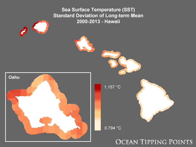
- Sea surface temperature (SST) plays an important role in a number of ecological processes and can vary over a wide range of time scales, from daily to decadal changes. SST influences primary production, species migration patterns, and coral health. If temperatures are anomalously warm for extended periods of time, drastic changes in the surrounding ecosystem can result, including harmful effects such as coral bleaching. This layer represents the standard deviation of SST (degrees Celsius) of the weekly time series from 2000-2013. Three SST datasets were combined to provide continuous coverage from 1985-2013. The concatenation applies bias adjustment derived from linear regression to the overlap periods of datasets, with the final representation matching the 0.05-degree (~5-km) near real-time SST product. First, a weekly composite, gap-filled SST dataset from the NOAA Pathfinder v5.2 SST 1/24-degree (~4-km), daily dataset (a NOAA Climate Data Record) for each location was produced following Heron et al. (2010) for January 1985 to December 2012. Next, weekly composite SST data from the NOAA/NESDIS/STAR Blended SST 0.1-degree (~11-km), daily dataset was produced for February 2009 to October 2013. Finally, a weekly composite SST dataset from the NOAA/NESDIS/STAR Blended SST 0.05-degree (~5-km), daily dataset was produced for March 2012 to December 2013. The standard deviation of the long-term mean SST was calculated by taking the standard deviation over all weekly data from 2000-2013 for each pixel.
- Title Sea Surface Temperature (SST) Standard Deviation of Long-term Mean, 2000-2013 - Hawaii
- creation Date 2017-03-14
- individual Name Carrie Kappel
- organisation Name Ocean Tipping Points (OTP)
- Contact information
-
- Address
-
- electronic Mail Address kappel@nceas.ucsb.edu
- Linkage for online resource
-
- name
- URL: http://oceantippingpoints.org
- protocol http
- link function information
- Description
- target application profile web browser
- individual Name Kim Selkoe
- organisation Name Ocean Tipping Points (OTP)
- Contact information
-
- Address
-
- electronic Mail Address selkoe@nceas.ucsb.edu
- Linkage for online resource
-
- name
- URL: http://oceantippingpoints.org
- protocol http
- link function information
- Description
- target application profile web browser
- organisation Name Pacific Islands Ocean Observing System (PacIOOS)
- Contact information
-
- Address
-
- electronic Mail Address info@pacioos.org
- Linkage for online resource
-
- name
- URL: http://pacioos.org
- protocol http
- link function information
- Description
- target application profile web browser
Theme keywords (theme):
Earth Science > Biosphere > Aquatic Ecosystems > Reef Habitat
Earth Science > Biosphere > Ecosystems > Marine Ecosystems > Reef > Coral Reef
Earth Science > Human Dimensions > Human Settlements > Coastal Areas
Earth Science > Oceans > Coastal Processes > Coral Reefs
Earth Science > Oceans > Ocean Temperature > Sea Surface Temperature
- Title GCMD Science Keywords
Location keywords:
Continent > North America > United States Of America > Hawaii
Ocean > Pacific Ocean > Central Pacific Ocean > Hawaiian Islands
- Title GCMD Location Keywords
project
Keywords
PacIOOS > Pacific Islands Ocean Observing System
- Title GCMD Project Keywords
dataCenter
Keywords
PacIOOS > Pacific Islands Ocean Observing System
- Title GCMD Data Center Keywords
Theme keywords (theme):
sea_surface_temperature
- Title CF Standard Name Table v39
Theme keywords (theme):
- Title Realm > Critical Zone
- publication Date 2018-11-21
Theme keywords (theme):
- Title Science Domain > Earth Science
- publication Date 2018-11-21
Theme keywords (theme):
- Title Realm > Geosphere
- publication Date 2018-11-21
Theme keywords (theme):
- Title Organization > GOVERNMENT AGENCIES-U.S. FEDERAL AGENCIES
- publication Date 2018-11-21
Theme keywords (theme):
- Title Feature > Marine Feature
- publication Date 2018-11-21
Theme keywords (theme):
- Title Material > Biological Material
- publication Date 2018-11-21
Theme keywords (theme):
- Title Realm > Habitat
- publication Date 2018-11-21
Theme keywords (theme):
- Title Property > Measure
- publication Date 2018-11-21
Theme keywords (theme):
- Title Resource Type > Dataset
- publication Date 2018-11-21
Theme keywords (theme):
- Title Organization > CONSORTIA/INSTITUTIONS
- publication Date 2018-11-21
Theme keywords (theme):
- Title Realm > marine
- publication Date 2018-11-21
purpose:
Browse image (thumbnail):
- Legal Constraints
-
- Use Limitation
- Please contact the Ocean Tipping Points (OTP) project in advance of applying these data to project work so that the principal investigator, Carrie Kappel (kappel@nceas.ucsb.edu), can track and communicate data uses and ensure no duplicate efforts are underway. The data may be used and redistributed for free but is not intended for legal use, since it may contain inaccuracies. Neither the data Contributor, University of Hawaii, PacIOOS, NOAA, State of Hawaii nor the United States Government, nor any of their employees or contractors, makes any warranty, express or implied, including warranties of merchantability and fitness for a particular purpose, or assumes any legal liability for the accuracy, completeness, or usefulness, of this information.
Resource extent
-
- extent Type Code 1
- westBoundLongitude -160.44646121838227
- eastBoundLongitude -154.53930597914805
- northBoundLatitude 22.4237406534364
- southBoundLatitude 18.75414421694241
Geographic Bounding Box
Geographic Extent
- The Ocean Tipping Points project, 2016. Please acknowledge the Ocean Tipping Points project as a source when these data are used in the preparation of reports, papers, publications, maps, and other products. When applying these data for publication, please reference and cite the following journal article: Wedding et al. (In review.) Advancing the Integration of Spatial Data to Map Human and Natural Drivers on Coral Reefs. Plos One.
- individual Name Carrie Kappel
- organisation Name Ocean Tipping Points (OTP)
- Contact information
-
- Address
-
- electronic Mail Address kappel@nceas.ucsb.edu
- Linkage for online resource
-
- name
- URL: http://oceantippingpoints.org
- protocol http
- link function information
- Description
- target application profile web browser
Service Identification information: 1
- Sea surface temperature (SST) plays an important role in a number of ecological processes and can vary over a wide range of time scales, from daily to decadal changes. SST influences primary production, species migration patterns, and coral health. If temperatures are anomalously warm for extended periods of time, drastic changes in the surrounding ecosystem can result, including harmful effects such as coral bleaching. This layer represents the standard deviation of SST (degrees Celsius) of the weekly time series from 2000-2013. Three SST datasets were combined to provide continuous coverage from 1985-2013. The concatenation applies bias adjustment derived from linear regression to the overlap periods of datasets, with the final representation matching the 0.05-degree (~5-km) near real-time SST product. First, a weekly composite, gap-filled SST dataset from the NOAA Pathfinder v5.2 SST 1/24-degree (~4-km), daily dataset (a NOAA Climate Data Record) for each location was produced following Heron et al. (2010) for January 1985 to December 2012. Next, weekly composite SST data from the NOAA/NESDIS/STAR Blended SST 0.1-degree (~11-km), daily dataset was produced for February 2009 to October 2013. Finally, a weekly composite SST dataset from the NOAA/NESDIS/STAR Blended SST 0.05-degree (~5-km), daily dataset was produced for March 2012 to December 2013. The standard deviation of the long-term mean SST was calculated by taking the standard deviation over all weekly data from 2000-2013 for each pixel.
- Title Sea Surface Temperature (SST) Standard Deviation of Long-term Mean, 2000-2013 - Hawaii
- creation Date 2017-03-14
- individual Name Carrie Kappel
- organisation Name Ocean Tipping Points (OTP)
- Contact information
-
- Address
-
- electronic Mail Address kappel@nceas.ucsb.edu
- Linkage for online resource
-
- name
- URL: http://oceantippingpoints.org
- protocol http
- link function information
- Description
- target application profile web browser
- organisation Name Pacific Islands Ocean Observing System (PacIOOS)
- Contact information
-
- Address
-
- electronic Mail Address info@pacioos.org
- Linkage for online resource
-
- name
- URL: http://pacioos.org
- protocol http
- link function information
- Description
- target application profile web browser
Resource extent
-
- extent Type Code 1
- westBoundLongitude -160.44646121838227
- eastBoundLongitude -154.53930597914805
- northBoundLatitude 22.4237406534364
- southBoundLatitude 18.75414421694241
Geographic Bounding Box
Geographic Extent
- Operation name: GetCapabilities
- Linkage for online resource
-
- name OGC-WCS
- URL: http://geo.pacioos.hawaii.edu/geoserver/PACIOOS/hi_otp_all_sst_std/ows?service=WCS&version=1.0.0&request=GetCapabilities
- protocol OGC:WCS
- link function download
- Description Open Geospatial Consortium Web Coverage Service (WCS). Supported WCS versions include 1.0.0, 1.1.0, and 1.1.1. Supported output formats include GeoTIFF, GIF, JPEG, PNG, or TIFF.
Service Identification information: 1
- Sea surface temperature (SST) plays an important role in a number of ecological processes and can vary over a wide range of time scales, from daily to decadal changes. SST influences primary production, species migration patterns, and coral health. If temperatures are anomalously warm for extended periods of time, drastic changes in the surrounding ecosystem can result, including harmful effects such as coral bleaching. This layer represents the standard deviation of SST (degrees Celsius) of the weekly time series from 2000-2013. Three SST datasets were combined to provide continuous coverage from 1985-2013. The concatenation applies bias adjustment derived from linear regression to the overlap periods of datasets, with the final representation matching the 0.05-degree (~5-km) near real-time SST product. First, a weekly composite, gap-filled SST dataset from the NOAA Pathfinder v5.2 SST 1/24-degree (~4-km), daily dataset (a NOAA Climate Data Record) for each location was produced following Heron et al. (2010) for January 1985 to December 2012. Next, weekly composite SST data from the NOAA/NESDIS/STAR Blended SST 0.1-degree (~11-km), daily dataset was produced for February 2009 to October 2013. Finally, a weekly composite SST dataset from the NOAA/NESDIS/STAR Blended SST 0.05-degree (~5-km), daily dataset was produced for March 2012 to December 2013. The standard deviation of the long-term mean SST was calculated by taking the standard deviation over all weekly data from 2000-2013 for each pixel.
- Title Sea Surface Temperature (SST) Standard Deviation of Long-term Mean, 2000-2013 - Hawaii
- creation Date 2017-03-14
- individual Name Carrie Kappel
- organisation Name Ocean Tipping Points (OTP)
- Contact information
-
- Address
-
- electronic Mail Address kappel@nceas.ucsb.edu
- Linkage for online resource
-
- name
- URL: http://oceantippingpoints.org
- protocol http
- link function information
- Description
- target application profile web browser
- organisation Name Pacific Islands Ocean Observing System (PacIOOS)
- Contact information
-
- Address
-
- electronic Mail Address info@pacioos.org
- Linkage for online resource
-
- name
- URL: http://pacioos.org
- protocol http
- link function information
- Description
- target application profile web browser
Resource extent
-
- extent Type Code 1
- westBoundLongitude -160.44646121838227
- eastBoundLongitude -154.53930597914805
- northBoundLatitude 22.4237406534364
- southBoundLatitude 18.75414421694241
Geographic Bounding Box
Geographic Extent
- Operation name: GetCapabilities
- Linkage for online resource
-
- name OGC-WMS
- URL: http://geo.pacioos.hawaii.edu/geoserver/PACIOOS/hi_otp_all_sst_std/ows?service=WMS&version=1.3.0&request=GetCapabilities
- protocol OGC:WMS
- link function download
- Description Open Geospatial Consortium Web Map Service (WMS). Supported WMS versions include 1.1.1 and 1.3.0. Supported map formats include AtomPub, GeoRSS, GeoTIFF, GIF, JPEG, KML/KMZ, PDF, PNG, SVG, and TIFF. Supported info formats include GeoJSON, GeoJSON-P, GML, HTML, and plain text.
Service Identification information: 1
- Sea surface temperature (SST) plays an important role in a number of ecological processes and can vary over a wide range of time scales, from daily to decadal changes. SST influences primary production, species migration patterns, and coral health. If temperatures are anomalously warm for extended periods of time, drastic changes in the surrounding ecosystem can result, including harmful effects such as coral bleaching. This layer represents the standard deviation of SST (degrees Celsius) of the weekly time series from 2000-2013. Three SST datasets were combined to provide continuous coverage from 1985-2013. The concatenation applies bias adjustment derived from linear regression to the overlap periods of datasets, with the final representation matching the 0.05-degree (~5-km) near real-time SST product. First, a weekly composite, gap-filled SST dataset from the NOAA Pathfinder v5.2 SST 1/24-degree (~4-km), daily dataset (a NOAA Climate Data Record) for each location was produced following Heron et al. (2010) for January 1985 to December 2012. Next, weekly composite SST data from the NOAA/NESDIS/STAR Blended SST 0.1-degree (~11-km), daily dataset was produced for February 2009 to October 2013. Finally, a weekly composite SST dataset from the NOAA/NESDIS/STAR Blended SST 0.05-degree (~5-km), daily dataset was produced for March 2012 to December 2013. The standard deviation of the long-term mean SST was calculated by taking the standard deviation over all weekly data from 2000-2013 for each pixel.
- Title Sea Surface Temperature (SST) Standard Deviation of Long-term Mean, 2000-2013 - Hawaii
- creation Date 2017-03-14
- individual Name Carrie Kappel
- organisation Name Ocean Tipping Points (OTP)
- Contact information
-
- Address
-
- electronic Mail Address kappel@nceas.ucsb.edu
- Linkage for online resource
-
- name
- URL: http://oceantippingpoints.org
- protocol http
- link function information
- Description
- target application profile web browser
- organisation Name Pacific Islands Ocean Observing System (PacIOOS)
- Contact information
-
- Address
-
- electronic Mail Address info@pacioos.org
- Linkage for online resource
-
- name
- URL: http://pacioos.org
- protocol http
- link function information
- Description
- target application profile web browser
Resource extent
-
- extent Type Code 1
- westBoundLongitude -160.44646121838227
- eastBoundLongitude -154.53930597914805
- northBoundLatitude 22.4237406534364
- southBoundLatitude 18.75414421694241
Geographic Bounding Box
Geographic Extent
- Operation name: GetCapabilities
- Linkage for online resource
-
- name OGC-WMS-C
- URL: http://geo.pacioos.hawaii.edu/geoserver/PACIOOS/gwc/service/wms?service=WMS&version=1.1.1&request=GetCapabilities&tiled=true
- protocol OGC:WMS-C
- link function download
- Description Open Geospatial Consortium Web Map Service - Cached (WMS-C). Use of WMS-C is similar to traditional WMS but with the addition of the "tiled=true" parameter, which triggers GeoServer to pull map tiles from GeoWebCache if they have been previously generated. This can dramatically improve performance, especially for larger datasets. Supported map formats include JPEG and PNG. Supported info formats include GeoJSON, GML, HTML, and plain text.
Grid spatial representation
- number of grid dimensions: 2
- Grid axis property:
-
- Grid Dimension
-
- Dimension Name: column
- Dimension Size 1253
- resolution
- Distance 0.00471065011103 degrees_east
- Grid Dimension
-
- Dimension Name: row
- Dimension Size 778
- resolution
- Distance 0.00471065011103 degrees_north
- cell geometry type: area
- transformation parameter availability:
Data quality information
Scope of quality information
- Lineage statement
- OGC web services (WMS and WCS) enabled by PacIOOS via GeoServer. Original data from source provider may have been reformatted, reprojected, or adjusted in other ways to optimize these capabilities.
Resource distribution information
Distributor
- individual Name
- organisation Name Pacific Islands Ocean Observing System (PacIOOS)
- Contact information
-
- Address
-
- electronic Mail Address info@pacioos.org
- Linkage for online resource
-
- name URL for the data publisher
- URL: http://pacioos.org
- protocol http
- link function information
- Description This URL provides contact information for the publisher of this dataset
- target application profile web browser
- Linkage for online resource
-
- name GeoServer
- URL: http://geo.pacioos.hawaii.edu/geoserver/
- protocol http
- link function download
- Description This URL provides access to this dataset via GeoServer, including multiple output formats and an OpenLayers viewer.
- Linkage for online resource
-
- name GeoExplorer
- URL: http://geo.pacioos.hawaii.edu/geoexplorer/
- protocol http
- link function download
- Description This URL provides a viewer for this dataset.
- Linkage for online resource
-
- name FGDC metadata
- URL: http://geo.pacioos.hawaii.edu/geoserver/www/metadata/hi_otp_all_sst_std.xml
- protocol text/xml
- link function information
- Description This URL provides additional metadata for this dataset from the source provider.
- Linkage for online resource
-
- name PacIOOS: Ocean Tipping Points (OTP) Data Viewer
- URL: http://pacioos.org/projects/oceantippingpoints/#data
- protocol http
- link function information
- Description This URL provides a viewer for this dataset.
- maintenance or update frequency:
- notes: This record was translated from GeoServer OGC Web Services (OWS) using PacIOOS software.
- individual Name Carrie Kappel
- organisation Name Ocean Tipping Points (OTP)
- Contact information
-
- Address
-
- electronic Mail Address kappel@nceas.ucsb.edu
- Linkage for online resource
-
- name
- URL: http://oceantippingpoints.org
- protocol http
- link function information
- Description
- target application profile web browser