Dataset Identification:
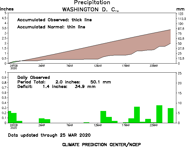
- The global precipitation time series provides time series charts showing observations of daily precipitation as well as accumulated precipitation compared to normal accumulated amounts for various stations around the world. These charts are created for different scales of time (30, 90, 365 days). Each station has a graphic that contains two charts. The first chart in the graphic is a time series in the format of a line graph, representing accumulated precipitation for each day in the time series compared to the accumulated normal amount of precipitation. The second chart is a bar graph displaying actual daily precipitation. The total accumulation and surplus or deficit amounts are displayed as text on the charts representing the entire time scale, in both inches and millimeters. The graphics are updated daily and the graphics reflect the updated observations and accumulated precipitation amounts including the latest daily data available. The available graphics are rotated, meaning that only the most recently created graphics are available. Previously made graphics are not archived.
- Title Climate Prediction Center (CPC) Global Precipitation Time Series
- publication Date 1997-01-01
- organisation Name Climate Prediction Center, National Centers for Environmental Prediction, National Weather Service, NOAA, U.S. Department of Commerce
- organisation Name Climate Prediction Center
- Contact information
-
- Address
-
- , ,
Theme keywords (theme):
Atmosphere > Precipitation > Precipitation Amount
- Title NASA GCMD Science Keywords
Theme keywords (theme):
precipitation
precipitation amount
- Title None
Location keywords:
Geographic Region > Global Land
- Title NASA GCMD Location Keywords
Stratum keywords:
Vertical Location > Land Surface
- Title NASA GCMD Location Keywords
Theme keywords:
climatologyMeteorologyAtmosphere
- Title ISO 19115 Topic Category
Theme keywords:
Atmosphere > Precipitation > Precipitation Amount
- Title NASA GCMD Science Keywords
purpose:
Browse image (thumbnail):
- maintenance or update frequency: daily
- Legal Constraints
-
- Access Constraints otherRestrictions
- use constraint: otherRestrictions
- Other constraints
- Access Constraints: None Use Constraints: Acknowledgment of the Data Originator when using the data item as a source. Distribution Liability: The user assumes the entire risk related to its use of this data. NWS is providing this data "as is," and NWS disclaims any and all warranties, whether express or implied, including (without limitation) any implied warranties of merchantability or fitness for a particular purpose. In no event will NWS be liable to you or to any third party for any direct, indirect, incidental, consequential, special or exemplary damages or lost profit resulting from any use or misuse of this data. As required by 17 U.S.C. 403, third parties producing copyrighted works consisting predominantly of the material appearing in NWS Web pages must provide notice with such work(s) identifying the NWS material incorporated and stating that such material is not subject to copyright protection. Refer the NOAA National Weather Service disclaimer; http://www.weather.gov/disclaimer.php
Resource extent
-
- westBoundLongitude -180
- eastBoundLongitude 180
- northBoundLatitude 90
- southBoundLatitude -90
Geographic Bounding Box - Temporal Extent
Geographic Extent
ground condition.
1997
2014-08-25T10:50:20.805-04:00
- Archives of these graphics are unavailable. The website only makes the latest updated graphics available. Example graphic in browse graphics file description section below contains two charts representing station-based observed precipitation in Washington D.C. for the latest 30-day period. The top chart is a time series of accumulated precipitation from the beginning to the end of the time period in the displayed time series. The values are displayed compared to the normal accumulated amount, which is the thin diagonal line in the chart. A green shaded area under a curve represents surplus precipitation values, whereas brown shaded areas represents deficit precipitation values. The bottom chart shows a bar graph of daily observed values in the same time period as the top chart. The period total and deficit is printed on the bottom chart. Both charts show the values on the left of the charts in inches and the right side of the chart in millimeters.
- Melissa Ou and George Fulwood are the primary members of the CPC working group in charge of the construction of this data set. Input data to the process is maintained by George Fulwood at CPC.
- organisation Name Climate Prediction Center, NOAA
- position Name Meteorologist
- Contact information
-
- Telephone
-
- Voice (301) 683-3414
- Fax (301) 683-1557
- Address
-
- 5830 University Research Court, College Park, MD, 20740
- electronic Mail Address Melissa.Ou@noaa.gov
Content information: feature catalog description
- Included With Dataset false
Data quality information
- Processing Step
-
- description Calculated daily accumulated precipitation (based on station observations) and estimated normal accumulated precipitation amounts are used to create the line plot chart in the graphic. Station observations of daily precipitation are used to display values in the bar graph chart in the graphic. Normal accumulated precipitation values are derived values and come from a dataset maintained by George Fulwood at CPC.
- processing agent contact - processor
-
- individual Name Melissa Ou
- organisation Name Climate Prediction Center
- position Name Meteorologist
- Contact information
-
- Telephone
-
- Voice (301) 683-3414
- Fax (301) 683-1557
- Address
-
- 5830 University Research Court, College Park, MD, 20740
- electronic Mail Address Melissa.Ou@noaa.gov
- hoursOfService 9 AM to 4 PM
- contact Instructions
- Call the office
- evaluation Method Description Quality control has been performed by viewing randomly selected graphics and matching it to generated station observations. This has also been done by other CPC staff members ongoing.
- evaluation Method Description Quality control has been performed by viewing randomly selected graphics and matching it to generated station observations. This has also been done by other CPC staff members ongoing.
- measure Description NA
- measure Description Quality of the analysis relies heavily on the input observational datasets used. There is quality controlling of these input datasets but the specifics of how each are checked must be inspected separately. Internal CPC members that have access to the data can evaluate the quality by accessing the GrADs control files and data. This data is not available to the public.
Resource distribution information
Distributor
- organisation Name NOAA's Climate Prediction Center
- position Name Meteorologist
- Contact information
-
- Telephone
-
- Voice (301) 683-3414
- Fax (301) 683-1557
- Address
-
- 5830 University Research Court, College Park, MD, 20740
- electronic Mail Address Melissa.Ou@noaa.gov
- fees None
- Format name Graphics Interchange Format (GIF)
- Format version
- file Decompression Technique Not compressed
- Linkage for online resource
- maintenance or update frequency:
- notes: This metadata was automatically generated from the FGDC Content Standard for Digital Geospatial Metadata standard version FGDC-STD-001-1998 using the January 2013 version of the FGDC RSE to ISO 19115-2 transform.
- organisation Name NOAA's Climate Prediction Center
- position Name Scientific Data Specialist
- Contact information
-
- Telephone
-
- Voice (301) 683-3412
- Fax (301) 683-1557
- Address
-
- 5830 University Research Court, College Park, MD, 20740
- electronic Mail Address sudhir.shrestha@noaa.gov