Dataset Identification:
- A bare earth elevation map (also known as a Digital Elevation Model, or DEM) of the Vicksburg National Military Park in Mississippi was produced from remotely sensed, geographically referenced elevation measurements cooperatively by the U.S. Geological Survey (USGS), National Park Service (NPS), and National Aeronautics and Space Administration (NASA). Elevation measurements were collected over the area using the NASA Experimental Advanced Airborne Research Lidar (EAARL), a pulsed-laser ranging system mounted onboard an aircraft to measure ground elevation, vegetation canopy, and coastal topography. The system uses high frequency laser beams directed at the Earth's surface through an opening in the bottom of the aircraft's fuselage. The laser system records the time difference between emission of the laser beam and the reception of the reflected laser signal in the aircraft. The plane travels over the target area at approximately 50 meters per second at an elevation of approximately 300 meters. The EAARL, developed by NASA at Wallops Flight Facility in Virginia, measures ground elevation with a vertical resolution of 15 centimeters. A sampling rate of 3 kilohertz or higher results in an extremely dense spatial elevation dataset. Over 100 kilometers of coastline can be easily surveyed within a 3- to 4-hour mission. When subsequent elevation maps for an area are analyzed, they provide resource managers with a useful tool regarding land development. For more information on Lidar science and the Experimental Advanced Airborne Research Lidar (EAARL) system and surveys, see http://ngom.usgs.gov/dsp/overview/index.php and http://ngom.usgs.gov/dsp/tech/eaarl/index.php .
- Title EAARL Topography-Vicksburg National Millitary Park 2008: Bare Earth
- publication Date 2008-01-01
- Name U.S. Geological Data Series
- Issue 390
- organisation Name U.S. Geological Survey
- Contact information
-
- Address
-
- , Saint Petersburg, FL
- organisation Name U.S. Geological Survey
- organisation Name
- Contact information
-
- Linkage for online resource
Theme keywords (theme):
elevation
- Title ISO Topic Keywords 19115
Theme keywords (theme):
Advanced Lidar Processing System
ALPS
Digital Elevation Model
DEM
EAARL
Experimental Advanced Airborne Research Lidar
laser altimetry
Lidar
remote sensing
topography
- Title http://remotesensing.usgs.gov
Location keywords:
Vicksburg National Military Park
Vicksburg
Mississippi
- Title http://nationalmap.gov
Stratum keywords:
bare earth
- Title http://lidar.cr.usgs.gov
Temporal keywords:
2008
- Title http://www.esri.com/news/arcuser/1104/temporal.html
Theme keywords (theme):
- Title Activity > Observation
- publication Date 2016-11-14
Theme keywords (theme):
- Title Organization > GOVERNMENT AGENCIES-U.S. FEDERAL AGENCIES
- publication Date 2016-11-14
Theme keywords (theme):
- Title Realm > Earth Surface
- publication Date 2016-11-14
Theme keywords (theme):
- Title Property > Measure
- publication Date 2016-11-14
Theme keywords (theme):
- Title Equipment > Instrument
- publication Date 2016-11-14
Theme keywords (theme):
- Title Equipment > platform
- publication Date 2016-11-14
Theme keywords (theme):
- Title Thing > Resource Type
- publication Date 2016-11-14
Theme keywords (theme):
- Title Material > Biological Material
- publication Date 2016-11-14
Theme keywords (theme):
- Title Thing > Process
- publication Date 2016-11-14
Theme keywords (theme):
- Title Feature > Environmental Feature
- publication Date 2016-11-14
Theme keywords (theme):
- Title Virtual International Authority File (VIAF) Corporate Names
- publication Date 2016-11-14
Theme keywords (theme):
- Title Feature > Physiographic Feature
- publication Date 2016-11-14
purpose:
Browse image (thumbnail):
- maintenance or update frequency: notPlanned
- Constraints
-
- Use limitation statement:
- This DVD publication was prepared by an agency of the United States Government. Although these data have been processed successfully on a computer system at the U.S. Geological Survey, no warranty expressed or implied is made regarding the display or utility of the data on any other system, nor shall the act of distribution imply any such warranty. The U.S. Geological Survey shall not be held liable for improper or incorrect use of the data described and (or) contained herein. Reference herin to any specific commercial product, process, or service by trade name, trademark, manufacturer, or otherwise does not constitute or imply its endorsement, recommendation, or favoring by the United States Government or any agency thereof.
- Legal Constraints
-
- use constraint: otherRestrictions
- Other constraints
- Use Constraints: The U.S. Geological Survey, National Park Service, and National Aeronautics and Space Administration request to be acknowledged as originators of this dataset in future products or derivative research.
- Legal Constraints
-
- Access Constraints otherRestrictions
- Other constraints
- Access Constraints: None
- Security Constraints
-
- Classification unclassified
- Classification System Unclassified
- Handling Description None
Resource extent
-
- westBoundLongitude -90.918242
- eastBoundLongitude -90.896584
- northBoundLatitude 32.321715
- southBoundLatitude 32.303323
Geographic Bounding Box - Temporal Extent
Geographic Extent
2008-03-06
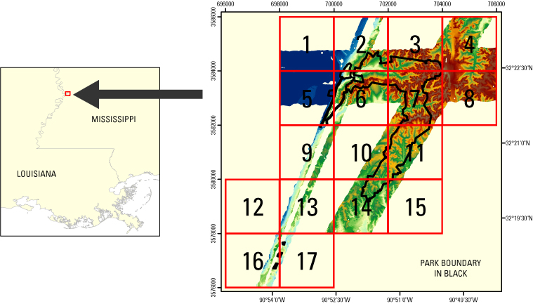
- Raw Lidar data are not in a format that is generally usable by Park Service resource managers and scientists for scientific analysis. Converting dense Lidar elevation data into a readily usable format without loss of essential information requires specialized processing. The U.S. Geological Survey's Coastal and Marine Geology (CMG) Program has developed custom software to convert raw Lidar data into a GIS-compatible map product to be provided to GIS specialists, managers, and scientists. The primary tool used in the conversion process is Airborne Lidar Processing System (ALPS), a multi-tiered processing system developed by a USGS-NASA collaborative project. Specialized processing algorithms are used to convert raw waveform Lidar data acquired by the EAARL to georeferenced spot (x,y,z) returns for "first surface" and "bare earth" topography. These data are then converted to the North American Datum of 1983 and the North American Vertical Datum of 1988 (using the GEOID03 model). Each file contains data located in a 2-km by 2-km tile, where the upper-left bound can be assessed quickly through the file name. The first 3 numbers in the file name represent the left-most UTM easting coordinate (e###000) in meters, the next 4 numbers represent the top-most UTM northing coordinate (n####000) in meters, and the last 2 numbers (##) represent the UTM zone in which the tile is located (for example, be_e123_n4567_15).The development of custom software for creating these data products has been supported by the USGS CMG Program's Decision Support for Coastal Parks, Sanctuaries, and Preserves Project. Processed data products are used by the USGS CMG Program's National Assessments of Coastal Change Hazards Project to quantify the vulnerability of shorelines to coastal change hazards such as severe storms, sea-level rise, and shoreline erosion and retreat.
- Acknowledgment of the U.S. Geological Survey, Florida Integrated Science Center, as a data source would be appreciated in products developed from these data, and such acknowledgment as is standard for citation and legal practices for data source is expected. Sharing of new data layers developed directly from these data would also be appreciated by the U.S. Geological Survey staff. Users should be aware that comparisons with other datasets for the same area from other time periods may be inaccurate due to inconsistencies resulting from changes in photointerpretation, mapping conventions, and digital processes over time. These data are not legal documents and are not to be used as such.
- individual Name Amar Nayegandhi
- organisation Name Jacobs Technology, U.S. Geological Survey, FISC, St. Petersburg, FL
- position Name Computer Scientist
- Contact information
-
- Telephone
-
- Voice 727 803-8747 (x3026)
- Fax 727-803-2031
- Address
-
- 600 4th Street South, Saint Petersburg, FL, 33701 Country USA
- electronic Mail Address anayegandhi@usgs.gov
Grid spatial representation
- number of grid dimensions: 3
- Grid axis property:
-
- Grid Dimension
-
- Dimension Name: row
- Dimension Size 2001
- Grid Dimension
-
- Dimension Name: column
- Dimension Size 2001
- Grid Dimension
-
- Dimension Name: vertical
- Dimension Size 1
- cell geometry type: point
- transformation parameter availability:
Content information: feature catalog description
- Included With Dataset false
Data quality information
Scope of quality information
- source
-
- source description Source Contribution: noneSource Type Point elevation measurements collected by the EAARL sensor.
- source citation
-
- Title EAARL Topography-Vicksburg National Military Park 2008: Bare Earth
- publication Date 2008-01-01
- Edition first
- presentationForm imageDigital
- Series
-
- Name U.S. Geological Survey Data Series
- Issue 390
- cited responsible party - publisher
-
- organisation Name U.S. Geological Survey
- Contact information
-
- Address
-
- , St. Petersburg, FL
- organisation Name U.S. Geoloigcal Survey
Resource extent
- Temporal Extent
2008-03-06
- name Of Measure Horizontal Positional Accuracy Report
- evaluation Method Description Raw elevation measurements have been determined to be within 1-meter horizontal accuracy.
- name Of Measure Vertical Positional Accuracy Report
- evaluation Method Description Elevations are vertically consistent with the point elevation data, +/-15 cm.
- evaluation Method Description Several regions of the dataset are labeled as "No Data", which corresponds to a cell value of -32767 m in the GeoTIFF file. These "No Data" areas are a result of the survey not covering a particular region, or the manual removal of Lidar processing artifacts.
- evaluation Method Description Several regions of the dataset are labeled as "No Data", which corresponds to a cell value of -32767 m in the GeoTIFF file. These "No Data" areas are a result of the survey not covering a particular region, or the manual removal of Lidar processing artifacts.
- measure Description Each file contains data located in a 2-km by 2-km tile, where the upper-left bound can be assessed quickly through the file name. The first 3 numbers in the file name represent the left-most UTM easting coordinate (e###000) in meters, the next 4 numbers represent the top-most UTM northing coordinate (n####000) in meters, and the last 2 numbers (##) represent the UTM zone in which the tile is located (for example, be_e123_n4567_15).
Resource distribution information
Distributor
- individual Name Project Manager
- organisation Name U.S. Geological Survey
- position Name Project Manager
- Contact information
-
- Telephone
-
- Voice 727-803-8747 (x3026)
- Address
-
- 600 4th Street South, Saint Petersburg, FL, 33701 Country USA
- fees Vary
- plannedAvailableDateTime 2008-03-06T00:00:00
- Ordering Instructions Ordering Instructions: Contact U.S. Geological Survey Custom Order Process: Contact U.S. Geological Survey for details.
- turnaround
- Vary
- Format name TIFF
- Format version 2
- specification > GeoTIFF
- Medium of distribution
-
- name dvd
- medium Format DVD
- maintenance or update frequency: annually
- notes: This metadata was automatically generated from the FGDC Content Standards for Digital Geospatial Metadata standard (version FGDC-STD-001-1998) using the 2012-06-20T17:21:00 version of the FGDC RSE to ISO 19115-2 transform.
- individual Name Xan Yates
- organisation Name Jacobs Technology, U.S. Geological Survey, FISC, St. Petersburg, FL
- position Name Metadata Specialist
- Contact information
-
- Telephone
-
- Voice 727-803-8747 (x3086)
- Address
-
- 600 4th Street South, Saint Petersburg, FL, 33701 Country USA