Dataset Identification:
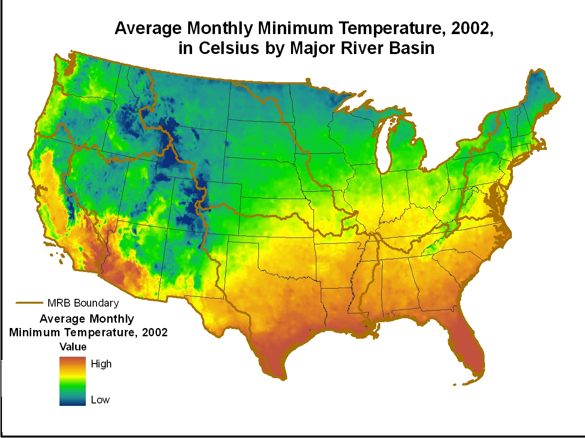
- This tabular data set represents the average daily minimum temperature in Celsius multiplied by 100 for 2002, compiled for every MRB_E2RF1 catchment of selected Major River Basins (MRBs, Crawford and others, 2006). The source data were the Near-Real-Time High-Resolution Monthly Average Maximum/Minimum Temperature for the Conterminous United States for 2002 raster data set produced by the Spatial Climate Analysis Service at Oregon State University. The MRB_E2RF1 catchments are based on a modified version of the Environmental Protection Agency's (USEPA) ERF1_2 and include enhancements to support national and regional-scale surface-water quality modeling (Nolan and others, 2002; Brakebill and others, 2011). Data were compiled for every MRB_E2RF1 catchment for the conterminous United States covering New England and Mid-Atlantic (MRB1), South Atlantic-Gulf and Tennessee (MRB2), the Great Lakes, Ohio, Upper Mississippi, and Souris-Red-Rainy (MRB3), the Missouri (MRB4), the Lower Mississippi, Arkansas-White-Red, and Texas-Gulf (MRB5), the Rio Grande, Colorado, and the Great basin (MRB6), the Pacific Northwest (MRB7) river basins, and California (MRB8).
- Title Attributes for MRB_E2RF1 Catchments by Major River Basins in the Conterminous United States: Average Daily Minimum Temperature, 2002
- publication Date 2010-01-01
- Name Digital Data Series
- Issue DS-491-30
- organisation Name U.S. Geological Survey
- Contact information
-
- Address
-
- , Reston, Virginia
- organisation Name Michael E. Wieczorek
- organisation Name Andrew E. LaMotte
- organisation Name
- Contact information
-
- Linkage for online resource
Theme keywords (theme):
Average monthly minimum temperature
Inland waters
MRB_E2RF1
MRB_E2RF1WS
Catchment
NAWQA
SPARROW
- Title None
Location keywords:
Conterminous United States
MRB
Major River Basins
MRB1
NEMA
New England and Mid-Atlantic
MRB2
SAGT
South Atlantic-Gulf and Tennessee
MRB3
GLMR
Great Lakes, Ohio, Upper Mississippi, and Souris-Red-Rainy
MRB4
MORI
Missouri
MRB5
LMTG
Lower Mississippi, Arkansas-White-Red, and Texas-Gulf
MRB6
COGB
Rio Grande, Colorado, and Great Basin
MRB7
PANW
Pacific Northwest
MRB8
CALI
California
- Title None
purpose:
Browse image (thumbnail):
- maintenance or update frequency: notPlanned
- Constraints
-
- Use limitation statement:
- Although this dataset has been used by the U.S. Geological Survey, U.S. Department of the Interior, no warranty expressed or implied is made by the U.S. Geological Survey as to the accuracy of the data and related materials. The act of distribution shall not constitute any such warranty, and no responsibility is assumed by the U.S. Geological Survey in the use of these data, software, or related materials. Any use of trade, product, or firm names is for descriptive purposes only and does not imply endorsement by the U.S. Government.
- Legal Constraints
-
- use constraint: otherRestrictions
- Other constraints
- Use Constraints: None
- Legal Constraints
-
- Access Constraints otherRestrictions
- Other constraints
- Access Constraints: None
Resource extent
-
- westBoundLongitude -127.910792
- eastBoundLongitude -65.327751
- northBoundLatitude 51.657387
- southBoundLatitude 23.243486
Geographic Bounding Box - Temporal Extent
Geographic Extent
2002-01-01
- individual Name Michael E. Wieczorek
- organisation Name U.S. Geological Survey
- Contact information
-
- Telephone
-
- Voice 443-498-5550
- Fax 443-498-5510
- Address
-
- 5522 Research Park Drive, Baltimore, MD, 21228 Country USA
- electronic Mail Address mewieczo@usgs.gov
Coverage description
- Type of coverage content
- Cell value attribute description:
- Band
-
- descriptor Percent of catchment that source GRID covers
- sequence Identifier
-
- name COV_PERC
- Long Wavelength 100.0
- Short Wavelength 0.0
- units
- Band
-
- descriptor Internal feature number
- sequence Identifier
-
- name OID
- Band
-
- descriptor Unique ID to relate to the item MRB_ID in the MRB_E2RF1WS catchment and MRB_E2RF1 reach coverages.
- sequence Identifier
-
- name RF1ID
- Band
-
- descriptor Area of catchment in square meters
- sequence Identifier
-
- name BASIN_AREA
- Long Wavelength 206651100000.0
- Short Wavelength 8100.0
- units
- Band
-
- descriptor Area of catchment that source GRID does not cover
- sequence Identifier
-
- name NODATA_ARE
- Long Wavelength 181703900000.0
- Short Wavelength 0.0
- units
- Band
-
- descriptor Average monthly minimum temperature in Celsius multiplied by 100 for 2002 for each catchment
- sequence Identifier
-
- name TMIN02_MEA
- Long Wavelength 2104.22
- Short Wavelength -931.094
- units
- Band
-
- descriptor Area of catchment that source GRID covers
- sequence Identifier
-
- name TMIN02_ARE
- Long Wavelength 24947240000.0
- Short Wavelength 0.0
- units
Content information: feature catalog description
- Included With Dataset true
- Feature Types
Data quality information
Scope of quality information
- source
-
- source description Source Contribution: The source data provided climate information.Source Type online
- source citation
-
- Title Near-Real-Time High-Resolution Monthly Average Maximum/Minimum Temperature for the Conterminous United States
- publication Date 9999-01-01
- presentationForm mapDigital
- other Citation Details Chris Daly, Wayne Gibson, Matthew Doggett, and Joseph Smith of the Spatial Climate Analysis Service at Oregon State University. George Taylor of the Oregon Climate Service at Oregon State University
- cited responsible party - publisher
-
- organisation Name Spatial Climate Analysis Service, Oregon State University
- Contact information
-
- Address
-
- , Corvallis, Oregon, USA
- organisation Name Chris Daly
- organisation Name Wayne Gibson
- organisation Name Matthew Doggett
- organisation Name Joseph Smith
- organisation Name George Taylor
- organisation Name
- Contact information
-
- Linkage for online resource
Resource extent
- Temporal Extent
2002-01-01
- source description Source Contribution: The modified version of the source data provided a reach network to construct reach catchments for MRBs and subsequent processing (J.W. Brakebill, U.S. Geological Survey, written commun., 2008).Source Type online
- source citation
-
- Title ERF1_2 -- Enhanced River Reach File 2.0
- publication Date 9999-01-01
- presentationForm mapDigital
- Series
-
- Name USGS Open-File Report
- Issue USGS Open-File Report 02-40
- organisation Name U.S. Geological Survey
- Contact information
-
- Address
-
- , Reston, Virginia
- organisation Name Jacqueline V. Nolan
- organisation Name John W. Brakebill
- organisation Name Richard B. Alexander
- organisation Name Gregory E. Schwarz
- organisation Name
- Contact information
-
- Linkage for online resource
Resource extent
- Temporal Extent
2002-01-01
- source description Source Contribution: The source data provided a reach network to construct reach catchments for MRBs and subsequent processing.Source Type online
- source citation
-
- Title A Digital Hydrologic Network Supporting NAWQA MRB SPARROW Modeling--MRB_E2RF1
- publication Date 2011-02-22
- presentationForm mapDigital
- Series
-
- Name General Information
- Issue Web Only
- organisation Name U.S. Geological Survey
- Contact information
-
- Address
-
- , Baltimore, MD
- organisation Name John W. Brakebill
- organisation Name Silvia E. Terziotti
- organisation Name
- Contact information
-
- Linkage for online resource
Resource extent
- Temporal Extent
2011-01-01
- source description Source Contribution: The source data provided reach catchments for MRBs and subsequent processing.Source Type online
- source citation
-
- Title A Digital Hydrologic Network Supporting NAWQA MRB SPARROW Modeling--MRB_E2RF1WS
- publication Date 2011-02-22
- presentationForm mapDigital
- Series
-
- Name General Information
- Issue Web Only
- organisation Name U.S. Geological Survey
- Contact information
-
- Address
-
- , Baltimore, MD
- organisation Name John W. Brakebill
- organisation Name Silvia E. Terziotti
- organisation Name
- Contact information
-
- Linkage for online resource
Resource extent
- Temporal Extent
2011-01-01
- evaluation Method Description None
- evaluation Method Description None
- measure Description None
Resource distribution information
Distributor
- organisation Name U.S. Geological Survey
- position Name Ask USGS -- Water Webserver Team
- Contact information
-
- Telephone
-
- Voice 1-888-275-8747 (1-888-ASK-USGS)
- Address
-
- 445 National Center, Reston, Virginia, 20192 Country USA
- electronic Mail Address http://water.usgs.gov/user_feedback_form.html
- fees None. This dataset is provided by the USGS as a public service.
- Format name dbf
- Format version
- file Decompression Technique zipped
- Format name dbf
- Format version
- file Decompression Technique zipped
- Format name dbf
- Format version
- file Decompression Technique zipped
- Format name dbf
- Format version
- file Decompression Technique zipped
- Format name dbf
- Format version
- file Decompression Technique zipped
- Format name dbf
- Format version
- file Decompression Technique zipped
- Format name dbf
- Format version
- file Decompression Technique zipped
- Format name dbf
- Format version
- file Decompression Technique zipped
- transfer Size 74 KB
- transfer Size 124 KB
- transfer Size 174 KB
- transfer Size 187 KB
- transfer Size 126 KB
- transfer Size 83 KB
- transfer Size 176 KB
- transfer Size 39 KB
- Linkage for online resource
-
- name dbf
- URL: http://water.usgs.gov/GIS/dsdl/mrb_e2rf1_tmin02_mrb1.zip
- Description Full coverage
- name dbf
- URL: http://water.usgs.gov/GIS/dsdl/mrb_e2rf1_tmin02_mrb2.zip
- Description Full coverage
- name dbf
- URL: http://water.usgs.gov/GIS/dsdl/mrb_e2rf1_tmin02_mrb3.zip
- Description Full coverage
- name dbf
- URL: http://water.usgs.gov/GIS/dsdl/mrb_e2rf1_tmin02_mrb4.zip
- Description Full coverage
- name dbf
- URL: http://water.usgs.gov/GIS/dsdl/mrb_e2rf1_tmin02_mrb5.zip
- Description Full coverage
- name dbf
- URL: http://water.usgs.gov/GIS/dsdl/mrb_e2rf1_tmin02_mrb6.zip
- Description Full coverage
- name dbf
- URL: http://water.usgs.gov/GIS/dsdl/mrb_e2rf1_tmin02_mrb7.zip
- Description Full coverage
- name dbf
- URL: http://water.usgs.gov/GIS/dsdl/mrb_e2rf1_tmin02_mrb8.zip
- Description Full coverage
- maintenance or update frequency: annually
- notes: This metadata was automatically generated from the FGDC Content Standards for Digital Geospatial Metadata standard (version FGDC-STD-001-1998) using the 2012-06-20T17:21:00 version of the FGDC RSE to ISO 19115-2 transform.
- organisation Name U.S. Geological Survey
- position Name Ask USGS -- Water Webserver Team
- Contact information
-
- Telephone
-
- Voice 1-888-275-8747 (1-888-ASK-USGS)
- Address
-
- 445 National Center, Reston, Virginia, 20192 Country USA
- electronic Mail Address http://answers.usgs.gov/cgi-bin/gsanswers?pemail=h2oteam&subject=GIS+Dataset+mrb_e2rf1_tmin02