Dataset Identification:
- Declination is calculated using the current International Geomagnetic Reference Field (IGRF) model. Declination is calculated using the current World Magnetic Model (WMM) or International Geomagnetic Reference Field (IGRF) model. While results are typically accurate to 30 minutes of arc, users should be aware that several environmental factors can cause disturbances in the magnetic field.
- Title Declination Calculator
- publication Date 2009-12-01
- organisation Name DOC/NOAA/NESDIS/NCEI > National Centers for Environmental Information, NESDIS, NOAA, U.S. Department of Commerce
- organisation Name DOC/NOAA/NESDIS/NCEI > National Centers for Environmental Information, NESDIS, NOAA, U.S. Department of Commerce
- position Name NCEI Geomagnetic Modeling Team
- Contact information
-
- Address
-
- electronic Mail Address geomag.models@noaa.gov
- Linkage for online resource
- organisation Name DOC/NOAA/NESDIS/NCEI > National Centers for Environmental Information, NESDIS, NOAA, U.S. Department of Commerce
- Contact information
-
- Linkage for online resource
Theme keywords (theme):
EARTH SCIENCE > Solid Earth > Geomagnetism > Magnetic Field
EARTH SCIENCE > Solid Earth > Geomagnetism > Magnetic Declination
- Title Global Change Master Directory (GCMD) Science and Services Keywords
- revision Date 2016-09-13
- organisation Name NASA
- position Name GCMD User Support Office
- Contact information
-
- Address
-
- electronic Mail Address gcmduso@gcmd.gsfc.nasa.gov
- Linkage for online resource
-
- name GCMD Feedback Form
- URL: http://gcmd.nasa.gov/MailComments/MailComments.jsf?rcpt=gcmduso
- link function information
- Description Have a Comment for the GCMD?
- organisation Name
- Contact information
-
- Linkage for online resource
-
- name GCMD's Science Keywords and Associated Directory Keywords
- URL: http://gcmd.nasa.gov/learn/keyword_list.html
- link function information
- Description This page describes the NASA GCMD Keywords, how to reference those keywords and provides download instructions.
Location keywords:
Geographic Region > Global
- Title Global Change Master Directory (GCMD) Location Keywords
- revision Date 2016-12-01
- organisation Name NASA
- position Name GCMD User Support Office
- Contact information
-
- Address
-
- electronic Mail Address gcmduso@gcmd.gsfc.nasa.gov
- Linkage for online resource
-
- name GCMD Feedback Form
- URL: http://gcmd.nasa.gov/MailComments/MailComments.jsf?rcpt=gcmduso
- link function information
- Description Have a Comment for the GCMD?
- organisation Name
- Contact information
-
- Linkage for online resource
-
- name GCMD's Science Keywords and Associated Directory Keywords
- URL: http://gcmd.nasa.gov/learn/keyword_list.html
- link function information
- Description This page describes the NASA GCMD Keywords, how to reference those keywords and provides download instructions.
dataCenter
Keywords
DOC/NOAA/NESDIS/NCEI > National Centers for Environmental Information, NESDIS, NOAA, U.S. Department of Commerce
DOC/NOAA/NESDIS/NGDC > National Geophysical Data Center, NESDIS, NOAA, U.S. Department of Commerce
- Title Global Change Master Directory (GCMD) Data Center Keywords
- revision Date 2016-12-01
- organisation Name NASA
- position Name GCMD User Support Office
- Contact information
-
- Address
-
- electronic Mail Address gcmduso@gcmd.gsfc.nasa.gov
- Linkage for online resource
-
- name GCMD Feedback Form
- URL: http://gcmd.nasa.gov/MailComments/MailComments.jsf?rcpt=gcmduso
- link function information
- Description Have a Comment for the GCMD?
- organisation Name
- Contact information
-
- Linkage for online resource
-
- name GCMD's Science Keywords and Associated Directory Keywords
- URL: http://gcmd.nasa.gov/learn/keyword_list.html
- link function information
- Description This page describes the NASA GCMD Keywords, how to reference those keywords and provides download instructions.
Theme keywords (theme):
- Title Property > Measure
- publication Date 2018-12-15
Theme keywords (theme):
- Title Science Domain > Earth Science
- publication Date 2018-12-15
Theme keywords (theme):
- Title Organization > GOVERNMENT AGENCIES-U.S. FEDERAL AGENCIES
- publication Date 2018-12-15
Theme keywords (theme):
- Title Virtual International Authority File (VIAF) Corporate Names
- publication Date 2018-12-15
Theme keywords (theme):
- Title Feature > Marine Feature
- publication Date 2018-12-15
purpose:
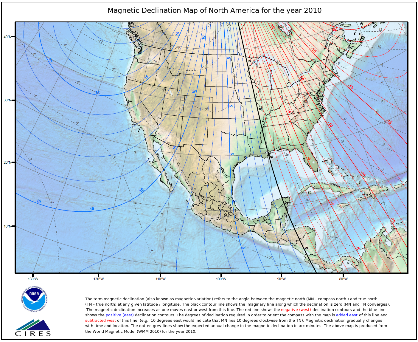
Browse image (thumbnail):
- maintenance or update frequency: asNeeded
- Constraints
-
- Use limitation statement:
- While every effort has been made to ensure that these data are accurate and reliable within the limits of the current state of the art, NOAA cannot assume liability for any damages caused by any errors or omissions in the data, nor as a result of the failure of the data to function on a particular system. NOAA makes no warranty, expressed or implied, nor does the fact of distribution constitute such a warranty.
- Constraints
-
- Use limitation statement:
- Produced by the NOAA National Geophysical Data Center. Not subject to copyright protection within the United States.
Resource extent
- Extent description
- The IGRF is a global model that extends back to the begining of the 20th Century and is updated every 5 years to include a forcast model for the following 5 years using observations of the Earth's magnetic field over time to interpolate
-
- westBoundLongitude -180
- eastBoundLongitude 180
- northBoundLatitude 90
- southBoundLatitude -90
Geographic Bounding Box - Temporal Extent
Geographic Extent
1900-01-01
2014-12-31
- organisation Name DOC/NOAA/NESDIS/NCEI > National Centers for Environmental Information, NESDIS, NOAA, U.S. Department of Commerce
- position Name NCEI Geomagnetic Modeling Team
- Contact information
-
- Address
-
- electronic Mail Address geomag.models@noaa.gov
- Linkage for online resource
Grid spatial representation
- number of grid dimensions: 3
- Grid axis property:
-
- cell geometry type: point
- transformation parameter availability: true
- descriptor Declination
- Long Wavelength 180
- Short Wavelength -180
- units
Reference system information
- Reference System Identifier
- Identifier string: urn:ogc:def:crs:EPSG::4326
- authority
-
- Title World Geodetic System 1984
- alternateTitle WGS 84
- revision Date 2007-08-27
- cited responsible party - resourceProvider
-
- organisation Name
- Contact information
-
- Linkage for online resource
-
- name WGS 84
- URL: http://www.epsg-registry.org/export.htm?gml=urn:ogc:def:crs:EPSG::4326
- link function information
- Description GML of World Geodetic System 1984 coordinate reference system.
- cited responsible party - publisher
-
- organisation Name European Petroleum Survey Group
- Contact information
-
- Linkage for online resource
-
- name European Petroleum Survey Group Geodetic Parameter Registry
- URL: http://www.epsg-registry.org/
- link function search
- Description Registry that accesses the EPSG Geodetic Parameter Dataset, which is a structured dataset of Coordinate Reference Systems and Coordinate Transformations.
quality statement 1
Scope of quality information
-
- other component described NOAA National Centers for Environmental Information
quality statement 2
Scope of quality information
- source
-
- source description The IGRF is the product of a collaborative effort between magnetic field modellers and the institutes involved in collecting and disseminating magnetic field data from satellites and from observatories and surveys around the world. The IGRF is a series of mathematical models of the Earth's main field and its annual rate of change (secular variation).
- source citation
-
- Title International Geomagnetic Reference Field 11
- alternateTitle IGRF 11
- revision Date 2010-10-12
- other Citation Details Report on the Reference Field. Equations and coefficients for the eleventh generation. DOI: 10.1111/j.1365-246X.2010.04804.x
- cited responsible party - resourceProvider
-
- organisation Name International Association of Geomagnetism and Aeronomy (IAGA)
- Contact information
-
- Linkage for online resource
-
- name International Geomagnetic Reference Field
- URL: https://www.ngdc.noaa.gov/IAGA/vmod/igrf.html
- link function information
- Description The International Association of Geomagnetism and Aeronomy (IAGA) has released the 11th Generation International Geomagnetic Reference Field, which is the latest version of a standard mathematical description of the Earth's main magnetic field that is used widely in studies of the Earth's deep interior, its crust and its ionosphere and magnetosphere.
Resource distribution information
Distributor
- organisation Name DOC/NOAA/NESDIS/NCEI > National Centers for Environmental Information, NESDIS, NOAA, U.S. Department of Commerce
- position Name NCEI Geomagnetic Modeling Team
- Contact information
-
- Address
-
- electronic Mail Address geomag.models@noaa.gov
- Linkage for online resource
- fees None
- Format name HTML Format
- Format version 1
- specification > The Declination Calculator creates an HTML pop-up window which superimposes a compass rose, indicating the declination, onto the location queried and reports the annual change in declination.
- distributor contact - pointOfContact
-
- organisation Name DOC/NOAA/NESDIS/NCEI > National Centers for Environmental Information, NESDIS, NOAA, U.S. Department of Commerce
- position Name NCEI Geomagnetic Modeling Team
- Contact information
-
- Address
-
- electronic Mail Address geomag.models@noaa.gov
- Linkage for online resource
Distributor
- Format name XML Format
- Format version 1
- specification > The Declination Calculator creates an XML file which reports the location and date queried as well as the declination and the annual change in declination in decimal minutes per year.
- distributor contact - distributor
-
- organisation Name DOC/NOAA/NESDIS/NCEI > National Centers for Environmental Information, NESDIS, NOAA, U.S. Department of Commerce
- Contact information
-
- Address
-
- electronic Mail Address geomag.models@noaa.gov
- Linkage for online resource
Distributor
- Format name CSV Format
- Format version 1
- specification > The Declination Calculator creates an Comma Seperated Variable (CSV) file which reports the location and date queried as well as the declination and the annual change in declination in decimal minutes per year.
- distributor contact - distributor
-
- organisation Name DOC/NOAA/NESDIS/NCEI > National Centers for Environmental Information, NESDIS, NOAA, U.S. Department of Commerce
- Contact information
-
- Address
-
- electronic Mail Address geomag.models@noaa.gov
- Linkage for online resource
Distributor
- Format name PDF Format
- Format version 1
- specification > The Declination Calculator creates a Portable Document Format file (PDF) file which reports the location and date queried as well as the declination and the annual change in declination in decimal minutes per year.
- distributor contact - distributor
-
- organisation Name DOC/NOAA/NESDIS/NCEI > National Centers for Environmental Information, NESDIS, NOAA, U.S. Department of Commerce
- Contact information
-
- Address
-
- electronic Mail Address geomag.models@noaa.gov
- Linkage for online resource
Distributor
- maintenance or update frequency: annually
- notes: Last Review Date: 2014-05-08
- notes: This record has been automatically modified to include references to NCEI where applicable on 2015-08-31.
- individual Name Brian Meyer
- organisation Name DOC/NOAA/NESDIS/NCEI > National Centers for Environmental Information, NESDIS, NOAA, U.S. Department of Commerce
- Contact information
-
- Telephone
-
- Voice 303-497-6125
- Address
-
- electronic Mail Address Brian.Meyer@noaa.gov