Dataset Identification:
- A digital elevation model (DEM) of a portion of the eastern Florida coastline, post-Hurricane Jeanne (September 2004 hurricane), was produced from remotely sensed, geographically referenced elevation measurements cooperatively by the U.S. Geological Survey (USGS) and the National Aeronautics and Space Administration (NASA). Elevation measurements were collected over the area using the Experimental Advanced Airborne Research Lidar (EAARL), a pulsed laser ranging system mounted onboard an aircraft to measure ground elevation, vegetation canopy, and coastal topography. The system uses high-frequency laser beams directed at the Earth's surface through an opening in the bottom of the aircraft's fuselage. The laser system records the time difference between emission of the laser beam and the reception of the reflected laser signal in the aircraft. The plane travels over the target area at approximately 50 meters per second at an elevation of approximately 300 meters, resulting in a laser swath of approximately 240 meters with an average point spacing of 2-3 meters. The EAARL, developed originally by NASA at Wallops Flight Facility in Virginia, measures ground elevation with a vertical resolution of +/-15 centimeters. A sampling rate of 3 kilohertz or higher results in an extremely dense spatial elevation dataset. Over 100 kilometers of coastline can be surveyed easily within a 3- to 4-hour mission. When resultant elevation maps for an area are analyzed, they provide a useful tool to make management decisions regarding land development. For more information on Lidar science and the Experimental Advanced Airborne Research Lidar (EAARL) system and surveys, see http://ngom.usgs.gov/dsp/overview/index.php and http://ngom.usgs.gov/dsp/tech/eaarl/index.php .
- Title EAARL Coastal Topography--Eastern Florida, Post-Hurricane Jeanne, 2004: Bare Earth
- publication Date 2011-01-01
- Name U.S. Geological Survey Data Series
- Issue 627
- organisation Name U.S. Geological Survey
- Contact information
-
- Address
-
- , St. Petersburg, FL
- organisation Name U.S. Geological Survey
- organisation Name
- Contact information
-
- Linkage for online resource
Theme keywords (theme):
Airborne Lidar Processing System
ALPS
Cessna 310
Digital Elevation Model
DEM
EAARL
Experimental Advanced Airborne Research Lidar
laser altimetry
lidar
remote sensing
topography
- Title General
Theme keywords (theme):
LAND SURFACE > TOPOGRAPHY > TERRAIN ELEVATION
OCEAN > COASTAL PROCESSES > BARRIER ISLANDS
OCEAN > COASTAL PROCESSES > BEACHES
OCEAN > COASTAL PROCESSES > SHORELINE DISPLACEMENT
DOI/USGS/CMG > COASTAL AND MARINE GEOLOGY, U.S. GEOLOGICAL SURVEY, U.S. DEPARTMENT OF INTERIOR
- Title Global Change Master Science Directory
Theme keywords (theme):
LIDAR > LIGHT DETECTION AND RANGING
- Title GCMD Instrument
Location keywords:
Brevard
Flagler
Indian River
Martin
Palm Beach
Saint Lucie
Saint Johns
Volusia
Florida
- Title Geographic Names Information System
Stratum keywords:
Bare Earth
- Title General
Temporal keywords:
2004
Post-Hurricane Jeanne
- Title General
Theme keywords (theme):
- Title Activity > Observation
- publication Date 2016-11-11
Theme keywords (theme):
- Title Feature > Hydrologic Feature
- publication Date 2016-11-11
Theme keywords (theme):
- Title Material > Environmental Material
- publication Date 2016-11-11
Theme keywords (theme):
- Title Property > Measure
- publication Date 2016-11-11
Theme keywords (theme):
- Title Science Domain > Earth Science
- publication Date 2016-11-11
Theme keywords (theme):
- Title Material > Biological Material
- publication Date 2016-11-11
Theme keywords (theme):
- Title Thing > Process
- publication Date 2016-11-11
Theme keywords (theme):
- Title Virtual International Authority File (VIAF) Corporate Names
- publication Date 2016-11-11
Theme keywords (theme):
- Title Feature > Physiographic Feature
- publication Date 2016-11-11
Theme keywords (theme):
- Title Organization > GOVERNMENT AGENCIES-U.S. FEDERAL AGENCIES
- publication Date 2016-11-11
Theme keywords (theme):
- Title Method > Information Processing
- publication Date 2016-11-11
Theme keywords (theme):
- Title Realm > Earth Surface
- publication Date 2016-11-11
Theme keywords (theme):
- Title Equipment > Instrument
- publication Date 2016-11-11
Theme keywords (theme):
- Title Equipment > platform
- publication Date 2016-11-11
Theme keywords (theme):
- Title Thing > Resource Type
- publication Date 2016-11-11
Theme keywords (theme):
- Title Feature > Marine Feature
- publication Date 2016-11-11
Theme keywords (theme):
- Title Feature > Environmental Feature
- publication Date 2016-11-11
Theme keywords (theme):
- Title Resource Type > Data Set
- publication Date 2016-11-11
purpose:
Browse image (thumbnail):
- maintenance or update frequency: notPlanned
- Constraints
-
- Use limitation statement:
- This DVD publication was prepared by an agency of the United States Government. Although these data have been processed successfully on a computer system at the U.S. Geological Survey, no warranty expressed or implied is made regarding the display or utility of the data on any other system, or for general or scientific purposes, nor shall the act of distribution constitute any such warranty. The U.S. Geological Survey shall not be held liable for improper or incorrect use of the data described and(or) contained herein. Neither the U.S. Government, the Department of the Interior, nor the USGS, nor any of their employees, contractors, or subcontractors, make any warranty, expressed or implied, nor assume any legal liability or responsibility for the accuracy, completeness, or usefulness of any information, apparatus, product, or process disclosed, nor represent that its use would not infringe on privately owned rights.
- Legal Constraints
-
- use constraint: otherRestrictions
- Other constraints
- Use Constraints: The U.S. Geological Survey and National Aeronautics and Space Administration request to be acknowledged as originators of these data in future products or derivative research.
- Legal Constraints
-
- Access Constraints otherRestrictions
- Other constraints
- Access Constraints: None
- Security Constraints
-
- Classification unclassified
- Classification System Unclassified
- Handling Description None
Resource extent
-
- westBoundLongitude -81.41513693
- eastBoundLongitude -79.97846296
- northBoundLatitude 30.10118552
- southBoundLatitude 26.75774353
Geographic Bounding Box - Temporal Extent
Geographic Extent
2004-10-01
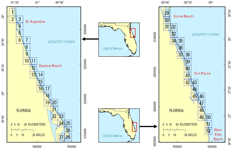
- Raw lidar data are not in a format that is generally usable by resource managers and scientists for scientific analysis. Converting dense lidar elevation data into a readily usable format without loss of essential information requires specialized processing. The U.S. Geological Survey's Coastal and Marine Geology Program (CMGP) has developed custom software to convert raw lidar data into a GIS-compatible map product to be provided to GIS specialists, managers, and scientists. The primary tool used in the conversion process is Airborne Lidar Processing System (ALPS), a multi-tiered processing system developed by a USGS-NASA collaborative project. Specialized processing algorithms are used to convert raw waveform lidar data acquired by the EAARL to georeferenced spot (x,y,z) returns for "first surface" and "bare earth" topography. The terms first surface and bare earth refer to the digital elevation data of the terrain, but while first-surface data include vegetation, buildings, and other manmade structures, bare-earth data do not. The zero crossing of the second derivative (that is, detection of stationary points) is used to detect the first return, resulting in "first surface" topography, while the trailing edge algorithm (that is, the algorithm searches for the location prior to the last return where direction changes along the trailing edge) is used to detect the range to the last return, or "bare earth" (the first and last returns being the first and last significant measurable portion of the return pulse). Statistical filtering, known as the Random Consensus Filter (RCF), is used to remove false bottom returns and other outliers from the EAARL topography data. The filter uses a grid of non-overlapping square cells (buffer) of user-defined size overlaid onto the original point cloud. The user also defines the vertical tolerance (vertical width) based on the topographic complexity and point-sampling density of the data. The maximum allowable elevation range within a cell is established by this vertical tolerance. An iterative process searches for the maximum concentration of points within the vertical tolerance and removes those points outside of the tolerance (Nayegandhi and others, 2009). These data are then converted to the North American Datum of 1983 and the North American Vertical Datum of 1988 (using the GEOID03 model). Each file contains data located in a 10-kilometer by 10-kilometer tile, where the upper-left bound can be assessed quickly through the filename. The first 3 numbers in the filename represent the left-most UTM easting coordinate (e###000) in meters, the next 4 numbers represent the top-most UTM northing coordinate (n####000) in meters, and the last 2 numbers (##) represent the UTM zone in which the tile is located (for example, be_e123_n4567_17).The development of custom software for creating these data products has been supported by the U.S. Geological Survey CMGP's Decision Support for Coastal Science and Management project. Processed data products are used by the U.S. Geological Survey CMGP's National Assessments of Coastal Change Hazards project to quantify the vulnerability of shorelines to coastal change hazards such as severe storms, sea-level rise, and shoreline erosion and retreat.
- Acknowledgment of the U.S. Geological Survey, St. Petersburg Coastal and Marine Science Center, as a data source would be appreciated in products developed from these data, and such acknowledgment as is standard for citation and legal practices for data source is expected. Sharing of new data layers developed directly from these data would also be appreciated by the U.S. Geological Survey staff. Users should be aware that comparisons with other datasets for the same area from other time periods may be inaccurate due to inconsistencies resulting from changes in photointerpretation, mapping conventions, and digital processes over time. These data are not legal documents and are not to be used as such.
- individual Name Amar Nayegandhi
- organisation Name Jacobs Technology, U.S. Geological Survey, St. Petersburg Coastal and Marine Science Center, St. Petersburg, FL
- position Name Remote Sensing Specialist/Project Manager
- Contact information
-
- Telephone
-
- Voice 727 803-8747 (x3026)
- Fax 727 803-2031
- Address
-
- 600 4th Street South, St. Petersburg, FL, 33701 Country USA
- electronic Mail Address anayegandhi@usgs.gov
Grid spatial representation
- number of grid dimensions: 2
- Grid axis property:
-
- Grid Dimension
-
- Dimension Name: row
- Dimension Size
- Grid Dimension
-
- Dimension Name: column
- Dimension Size
- cell geometry type: point
- transformation parameter availability:
Content information: feature catalog description
- Included With Dataset false
Data quality information
Scope of quality information
- name Of Measure Horizontal Positional Accuracy Report
- evaluation Method Description Raw elevation measurements have been determined to be within 1 meter in horizontal accuracy.
- name Of Measure Vertical Positional Accuracy Report
- evaluation Method Description Typical vertical elevation accuracies for these data are consistent with the point elevation data, +/-15 centimeters. However, a ground-control survey is not conducted simultaneously with every lidar survey. Vertical accuracies may vary based on the type of terrain and the accuracy of the GPS and aircraft-attitude measurements.
- evaluation Method Description Several regions of the dataset are labeled as "No Data," which corresponds to a cell value of -32767 meters in the GeoTIFF file. These "No Data" areas are a result of the survey not covering a particular region, optical water depth of greater than 1.5 Secchi disc depths, or the manual removal of lidar processing artifacts. The presence of "No Data" values does not necessarily indicate an absence of land, but rather an absence of survey coverage or the presence of prolific vegetation that the laser is not able to penetrate in order to return bare-earth data. This metadata file is generalized; each data file on this DVD has its own corresponding metadata file.
- evaluation Method Description Several regions of the dataset are labeled as "No Data," which corresponds to a cell value of -32767 meters in the GeoTIFF file. These "No Data" areas are a result of the survey not covering a particular region, optical water depth of greater than 1.5 Secchi disc depths, or the manual removal of lidar processing artifacts. The presence of "No Data" values does not necessarily indicate an absence of land, but rather an absence of survey coverage or the presence of prolific vegetation that the laser is not able to penetrate in order to return bare-earth data. This metadata file is generalized; each data file on this DVD has its own corresponding metadata file.
- measure Description Each file contains data located in a 10-kilometer by 10-kilometer tile where the upper-left bound can be assessed quickly through the filename. The first 3 numbers in the filename represent the left-most UTM easting coordinate (e###000) in meters, the next 4 numbers represent the top-most UTM northing coordinate (n####000) in meters, and the last 2 numbers (##) represent the UTM zone in which the tile is located (for example, be_e123_n4567_17).
Resource distribution information
Distributor
- individual Name Amar Nayegandhi
- organisation Name U.S. Geological Survey
- position Name Remote Sensing Specialist/Project Manager
- Contact information
-
- Telephone
-
- Voice 727 803-8747 (x3026)
- Address
-
- 600 4th Street South, St. Petersburg, FL, 33701 Country USA
- fees Vary
- plannedAvailableDateTime 2004-10-01T00:00:00
- Ordering Instructions Ordering Instructions: Contact U.S. Geological Survey. Custom Order Process: Contact U.S. Geological Survey for details.
- turnaround
- Vary
- Format name GeoTIFF
- Format version 2
- specification > GeoTIFF
- Medium of distribution
-
- name dvd
- medium Format DVD
- maintenance or update frequency: annually
- notes: This metadata was automatically generated from the FGDC Content Standards for Digital Geospatial Metadata standard (version FGDC-STD-001-1998) using the 2012-06-20T17:21:00 version of the FGDC RSE to ISO 19115-2 transform.
- individual Name Xan Fredericks
- organisation Name Jacobs Technology, U.S. Geological Survey, St. Petersburg Coastal and Marine Science Center, St. Petersburg, FL
- position Name Geologist/GIS Analyst/Metadata Specialist
- Contact information
-
- Telephone
-
- Voice 727 803-8747 (x3086)
- Address
-
- 600 4th Street South, St. Petersburg, FL, 33701 Country USA
- electronic Mail Address afredericks@usgs.gov